Mell and Gowbarrow Fells

Saturday, 24 May 2014
6.9miles/11.1km
2329ft/710m ascent
Wainwright #147, #148 & #149


Yesterday we walked in cloud and the only hills where we could see the summits were the low fells to the north of Ullswater. So today, with a similar forecast, we set off to climb all three of these smaller hills in separate walks.

The first hill is Little Mell Fell (1,657ft/505m). This is a very short ascent from the road and took us twenty minutes of walking – an uphill slog all the way. Wainwright dismisses this hill, questioning why he included it in his guide books, but its location as the last significant bump at the North Eastern edge of the Lake District provides it with a good view of all the hills in this part of England.

Little Mell Fell Next, is the nearby Great Mell Fell (1,762ft/537m) a hill with a similar shape; but a completely different ‘feel’. Little Mell Fell, like most Lakeland fells, is grazed and the sheep keep the surface a smooth, treeless green grass slope.  Great Mell Fell in contrast is fenced and has no sheep, the result is a tree covered hill.

Climbing Great Mell FellTrees on Great Mell Fell

More Trees

Now owned by the National Trust, Great Mell Fell was previously the site of a firing range and Wainwright’s guide, written many years ago, advises not attempting to climb it – for fear of getting shot!  The result is a climb through a fabulous wood with trees bent and blown over by the prevailing South-Westerly winds.

Hare Tail Cotton GrassGreat Mell Fell

The summit is grassy and the cotton grass was just flowering – leaving a field of small white fluff balls blowing in the wind as we descended back to the car.

The final climb for the day was Gowbarrow Fell (1,579ft/481m). This is the knobbly brown hill that lies behind the popular waterfall of Aira Force.

Aira ForceBy the Waterfall

We walked up the paved pathways from the busy National Trust car park to the waterfall. Stopped to take some photographs and then set off following our noses (rather than the map) towards the top. Our aim was to get up and down before the rain forecast for mid-afternoon.

UllswaterGreat Mell Fell from Gowbarrow

Gowbarrow Fell reminded me very much of Loughrigg Fell (1,099ft/335m) or Silver How (1,296ft/395m), a low hill with a bump coated top, lots of false summits and paths winding in all directions. We followed what seemed to be the main path and were surprised at how long it took before the summit finally came into view.

Gowbarrow Fell

We got back down and ate an ice cream in the car park, which was full of visiting Sri-Lankan cricket fans visiting the waterfall the day before the first match.


Route

Three separate walks, starting from three different locations:

Little Mell Fell: at the road (NY424235).
Great Mell Fell: at the road (NY407247).
Gowbarrow Fell: at the National Trust car park (NY401201).

Mell Fells Route


High Pike (Caldbeck)

Friday, 23 May 2014
7.4miles/11.8km
1650ft/500m ascent
Trail 100 #37
Wainwright #145 & #146


A poor weather forecast with high winds made us abandon the walk we had planned and go for a less craggy route in the far North of the Lake District.  The Caldbeck Fells are wild, have few visitors and are scarred with the remains of intensive mining.

We set off (typically) by walking straight up the hill following a steep ravine. Very pretty with views towards Ullswater and occasional trees sprouting from the crags.

The Route UpTree on a Crag

However, as we neared the top of the hill we disappeared into the mist which would remain with us for the rest of the ridge walk.Disappearing in to the Mist

I enjoy the challenge of navigating with map and compass without being able to ‘cheat’ by using visual clues; and today we managed to follow our chosen route over Carrock Fell (2,175ft/663m), Round Knott (1,978ft/803m), Miton Hill (1,991ft/607m) and High Pike (2,159ft/658m).  I did use a GPS to confirm our location on two occasions.Carrock Fell 2Carrock Fell 1

The summit of Carrock Fell was an Iron Age hill fort and the remains of the stone walls cover the plateau.  They looked eerie in the mist.  The terrain between Carrock Fell and High Pike is boggy and covered with a scattering of small pools.

High PikeThe summit of High Pike has three features: a stone bench, a trig point and a stone shelter where we ate our lunch.  The view from the bench at the top is supposed to be wonderful.  We didn’t see anything as we sat and ate our sandwiches in the cloud.

Great View on a Clear Day
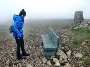
We rejoined the miners track and quickly dropped below the cloud.  Now able to see, we walked passed the old mine shafts and huge piles of debris; discarded piles of stone and brightly coloured gashes in the green grass covered hill.


Dropping Below the CloudsOld Mine Shaft

Back at the road we walked across Caldbeck Common, stopping to chat to the sheep and ponies.  No apples, so we couldn’t feed them.  We crossed the stream by the bridge, and walked back to the car with a splendid view of Little Mell Fell (height), Great Mell Fell (height), Gowbarrow Fell (height) and Place Fell (height).

Carrock Fell and Howthwaite StoneTalking to More AnimalsBaaaOn a BridgeGreat Mell Fell and Place Fell


Route

Starting at the road (NY354337).

High Pike Route

Fairfield

Friday, 18 April 2014
10.2 miles/16.5km
3260ft/994m ascent
Trail 100 #31 & #32
Wainwright #140

Fairfield (2,864ft/873m) is a very popular mountain. Good Friday is the traditional start of the hiking season. The sun is shining, clear blue skies all day. The popular routes up Fairfield are going to be very, very busy; a steady stream of hikers walking up the well trodden paths from Grasmere, Ambleside and Patterdale. We stopped to take a ‘selfie’ by Goldrill Beck before starting our walk.

Goldrill BeckSetting off in the Sunshine

Our route was from Patterdale up Deepdale, and when that got too crowded (with one other couple), we left the path and headed up the steep rock strewn, grassy slope that winds around Greenhow End.

Greenhow End

We stopped to watch a Peregrine Falcon feeding young on a nest on the crag. And crags are the major feature of this route. Looking up from the valley floor, Hart Crag (2,697ft/822m) and Fairfield look an unpromising route, but once you know, there is a clear route.  There is no path here, but from a distance a grassy strip ascends winding in a mirrored ‘S’ shape around Greenhow End to the top of Fairfield.

I promised to mention drumlins in this post.  Here is a photograph of the field of drumlins lying, where the glacier left them, at top of Deepdale.

Drumlins

Wainwright does not recommend this ascent, but for those with strong legs and a a desire to walk on less trodden paths, this is a superb way up a fantastic mountain.

The StepHigh Street


The views of the central Lake District fells and the Helvellyn ridge are breathtaking.  We ate lunch on the crowded top and then followed the more traditional steep scree covered path down over Cofa Pike (2,700ft/823m) and St Sunday Crag (2,759ft/841m) following the ridge.

HelvellynCofa Pike and St Sunday CragGrisedale TarnDeepdaleCofa PikeFairfield

From there we diverted onto the grassy bank of Birks (2,041ft/622m) and then quickly down to Arnison Crag (1,421ft/433m), which has a great view of Patterdale and Ullswater.

Arnison CragBirks


Route

From the car park in Patterdale (NY396160)

Fairfield Route

Beda Fell

Wednesday, 16 April 2014
9.7 miles/15.6km
2950ft/899m ascent
Wainwright #137, #138 & #139

Today we thought we deserved a break from ten mile hikes and 3,000 feet ascents.  So we caught the Ullswater Steamer to Howtown and walked up and down Hallin Fell (1,273ft/388m); and up and down Steel Knotts (1,417ft/432m); and then up and down Beda Fell (1,670ft/509m).  We were quite surprised when this turned out to be about ten miles long and 3,000 feet climbing.

There was a cold wind on the lake, so we huddled with hats, gloves and coats for the half hour boat ride to the start of our walk.  Our first hill is Hallin Fell and we sped up the grassy slopes from the church in Martindale.  The huge pillar on the summit is quite distinctive and we were lucky to get a photo of the famous ‘Hound of Hallin Fell’ peering out from behind the cairn.

Ullswater SteamerHallin Fell

We hurried back the way we came and set off again along the ridge of Steel Knotts.  To the East the huge High Street range rising to Rampsgill Head (2,598ft/792m) fills the view; and Place Fell (2,156ft/657m) dominates the view to the West; but there are pleasant glimpses of Ullswater and The Nab (1,890ft/576m) as you climb to the summit (Pikeawassa) with it’s unusual pointed rock top.

HowtownThe Nab

We walked back down and some hours after we set off were on the valley floor less than a mile from the lakeside pier where we started our walk.  Our final, and highest  hill for the day is the long ridge of Beda Fell which forms the Eastern side of Boredale.

Beda HeadHelvellyn from Beda Fell

We followed the familiar route back down Boredale Hause to Patterdale in warm sunshine and managed to find the easier lower path.


Route

Parked in Glenridding (NY389169) and caught the Ullswater Steamer to Howtown.

Beda Fell Route