Cross Fell

Sunday, 29 June 2014
13.4miles/8.4km
2283ft/696m ascent
Trail 100 #43


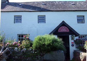
Over a big breakfast at The Coach House we discussed what to do.  We had finished our planned walks for the weekend a day early.  Afterwards Sue let us know what she would have done: ‘Gone for a mooch around and gone to a coffee shop’ – a good suggestion for a summer Sunday.

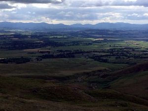
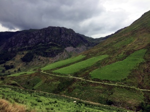
We stopped off in Hexham on the drive back from Northumberland and bought a map before climbing the largest mountain in the Pennines.  At 2,930ft/893m Cross Fell is one of the largest hills in England but, because it lies outside the big hill walking areas (The Lake District or Snowdonia), it isn’t a popular climb.  Which is a shame, because it is good walk and the view to the West of the nearby Lake District fells is superb.

Bridleway

We walked up the bridleway, always a good route up a mountain as the path tends to be wider and less steep.  Once over the first shoulder of the fell the ground becomes boggy before rising to a fortress of loose rock and scree.

ScreesDescent

The top is a flat expanse of grass with a scattering of stones which have been built into a series of cairns and shelters.  The large white golf-ball shaped radar dome on Great Dun Fell is prominent to the South, but it is the panoramic view of the Lake District fells to the West which is fantastic.

Shelter Pennine Way Cairn Lake District SkylineSummit

We charged down the mountain using the same route and got back in time to listen to the Netherlands vs Mexico World Cup football match on the way back home.


Route

From the road at  NY646325.

Cross Fell Route

Cadair Idris

Sunday, 15 June 2014
6.3miles/10.2km
3028ft/923m ascent
Trail 100 #40


Our base for this weekend was the LLwyndu Farmhouse in Barmouth, where we ate a filling breakfast before setting out to climb the most famous mountain in this part of Wales.

LLwyndu Farmhouse

The location of Cadair Idris (2930ft/893m) rising from sea level above the Mawddach Estuary is an impressive sight, but we decided to climb it from the other side, starting at Minffordd. The first part of the walk is a steep stepped ascent following a stream through woods that provided shelter from the sun.

Afon Faw and Dol Idris

At the fork in the path we turned left and headed towards Cwm Cau quickly arriving at the small lake surrounded by the huge cliff walls on three sides. In this sheltered hollow the water was flat smooth with a perfect reflection of the blue sky.  From there the path climbs to reach the ridge.

Llyn Cau


It is this ridge walk that makes this route so superb.  The other routes up miss this spectacular view with the summit (Penygadair) clearly visible as the goal providing motivation for the climb.  Even this same route in the opposite direction would miss the joy of this climb.

Craig CauCraig Cwm AmarchHerring GullCardigan Bay

And then the crowded summit, where we stopped for lunch and enjoyed the view over the sea and down to Barmouth with its distinctive railway bridge crossing the estuary.

Cadair Idris

From there the path descends over a rock strewn grass field before rising gently to Mynydd Moel.

The Ridge from Mynydd Moel Cliffs at Mynydd Moel

The descent was by a steep path covered in loose rock and stone, a difficult surface to walk on which made us slow, we felt sorry for those we passed climbing this path.  We stopped at the tea room for a drink.

Us


Route

From the car park at SH732115.

Cadair Idris Route


Aran Fawddwy

Saturday, 14 June 2014
7.9miles/12.8km
2736ft/834m ascent
Trail 100 #39


We ate lunch in the new car park at the end of the valley and set off walking just after half past two. Aran Fawddwy (2969ft/905m) looks impressive, a sharp ridge rising to nearly 3000 feet. We had past it on Friday night driving to Barmouth, and it was clearly visible from the top of Maesglase (2218ft/676m).

There are two popular routes: down the ridge from the Southern end of Lake Bala; and our route via Drysgol. Both routes are long and, with our tired legs, the ascent was punishing, the first two miles a relentless climb up a good straight path rising from the valley of Hengwm to reach the ridge.

Hengwm

From this point onwards Aran Fawddwy is a joy. The path curves over a gentle grass covered ridge and the view opens up: first revealing the Aran ridge itself with the little lake (Creiglyn Dyfi) nestling below the crags of Aran Benllyn (2904ft/885m); and then, as you reach the stone scattered top, the whole panorama of the Snowdonian mountains.

Creiglyn DyfiAran Benllyn

Bathed in evening sunshine we had the top of this popular mountain to ourselves.

It was now late, and we had dinner booked, so we marched down an increasingly boggy path with rotting duck boards covering the worst.  The view to the south dominated by the spiky crown of Cadair Idris (2930ft/893m).

Cadair Idris

Together, today’s two walks were the longest, furthest and highest of the year so far: over 14 miles (23km), just short of 5000 feet (1500m) of climbing and over eight hours on our feet.  A steaming hot bath and dinner were waiting at our hotel.

Descent


Route

From the car park at SH852188.

Aran Fawddwy Route

Maesglase

Saturday, 14 June 2014
6.3miles/10.2km
2215ft/675m ascent
Trail 100 #38


The Trail 100 list of great mountains in the United Kingdom has impressed us until today.  All of the other hills have either been spectacular, or have possessed stunning views, or both!  Maesglase (2218ft/676m) failed to deliver.

It was a pleasant climb to the top, and the woods and waterfalls were nice – but there was nothing dramatic or spectacular about the route we chose.  The view from the top?  You could see the spiky crown of Cadair Idris (2930ft/893m) and the long dark ridge of Aran Fawddwy (2969ft/905m), but they were distant – there was nothing spectacular about this mountain.

So, after three hours walking in the sunshine we got in the car and drove a few miles to the foot of our next hill, hoping for something better.

WaterfallMaesglase

Here’s Gillian explaining to a lost lamb that mummy sheep is ‘just over there’.

Lamb


Route

From the lay-by on the A470 at SH848155.

Maesglase Route


Y Garn & Elidir Fawr

Sunday, 30 March 2014
8.7miles/14.0km
4130ft/1260m ascent
Trail 100 #28
3000ft #17 & #18


Y Garn - Llyn IdwalDespite losing an hours sleep to the clock change we arrived bright and early at the Ogwen Cottage car park just after nine. The Vistor’s Centre has been rebuilt since our last visit.

Cwm IdwalY Garn - Idwal Slabs

We followed all the rock climbers up as far as the Idwal slabs and then had the path to ourselves as we climbed the Devil’s Kitchen. This is a gash in the cliff where a waterfall gushes down the mountain side to Llyn Idwal. The steep rocky scramble passes to the left of the cleft and climbs to Llyn y Cwn.


 Y- Garn - Devil's KitchenY Garn - Glyder Fawr

Y Garn - Llyn y Cwn
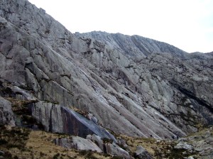
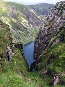
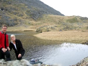
Llyn y Cwn is a small mountain lake nestled at the foot of the huge Glyder Fawr (3,283ft/1001m).

An ideal place for a breather, a snack, a photograph and watching the other walkers struggling up the scree towards the Glyders. Once replenished we set off for our first summit – Y Garn (3,107ft/947m).


Y Garn

The path can be clearly seen first crossing the grassy slope and then over the steeper rockier ground as you approach the top. The summit is very rocky, but easier than the top of Tryfan (3,010ft/918m) whose distinctive summit is just visible on the left.

Y GarnY Garn - Summit

Leaving the summit of Y Garn you can see the path as it passes over Foel Goch (2,641ft/831m) (the nearest pointed hill with the Menai Straits and Anglesey beyond) and along the ridge to Elidir Fawr (3,031ft/924m).

Y Garn - Ridge to Elidir Fawr

Foel Goch

The path to Foel Goch is easy and grass covered and comes to an abrupt end when you reach the cliff edge. The view from this smaller mountain is stunning – looking down into the Ogwen Valley (Nant Ffrancon), across to Elidir Fawr or back to Y Garn – there are 3,000ft mountains in every direction.

Foel Goch - Tryfan Foel Goch - Elidir FawrFoel Goch - Y Garn

Elidir Fawr

We stopped for lunch near the col before attempting the ridge to Elidir Fawr. Like all the Glyders the summit is rocky and you make your own path to the top. From the top we could see around Snowdon (3,560ft/1085m) and make out the distinct pyramid of Moel Hebog (2,569ft/783m).

Elidir Fawr - Summit Elidir Fawr

Looking East from the summit of Elidir Fawr this spectacular view shows the sheer scale of the mountains with the cut-off ridge at Foel Goch and the huge mountains beyond. The big black cliffs of Pen-yr Ole Wen (3,209ft/978m) are the same height as Scafell Pike. Behind are Carnedd Dafydd (3,425ft/1044m) and Carnedd Llewelyn (3,491ft/1064m). Our route takes us over Foel Goch and down to the foot of Pen-yr Ole Wen and the car park.Elidir Fawr - Foel Goch

We plunged down the steep scree covered slope into the cwm below. Then followed the contour around until we could see Llyn Idwal and the main path back to the car.

Elidir Fawr - Llyn Idwal


Route

Starting at the Ogwen Cottage car park  (SH648604).


Y Garn & Elidir Fawr Route

Moel Hebog

Saturday, 29 March 2014
4.9miles/7.9km
2400ft/730m ascent
Trail 100 #27


Manchester United and Aston Villa delayed our departure for North Wales. We drove through Betwys-y-Coed waving at Sue and John as we passed. So it was after 4pm before we set off to climb Moel Hebog (2569ft/783m). This mountain rises with a huge pyramid shaped cliff just West of Beddgelert. We passed three guys on their way down who commented it was a little late to be setting off for the summit. We reassured them that we’d be up and down within two hours – and we were!

Moel Hebog - Cliffs

Given the time we took the most direct route there and back. This is a steep slog up the front and then a scramble up the edge of the cliff to reach the flat grass topped summit. I think the slope is about 1 in 4 for the whole 2 kilometers.

The weather was peculiar. The climb was made difficult as a strong wind swept around the crags and buffeted us all the way up and back down – but the actual summit was almost still as the sun started to dip behind the mountains.

Moel HebogMoel Hebog - Trig  Moel Hebog - At the TopMoel Hebog - Beddgelert Valley

Add New


Route

Starting at the Beddgelert car park  (SH588481).

Moel Hebog Route